
Goldsboro Street Directory Walkthrough
A Goldsboro street directory search works best as a chain, not a single result. Wayne Tax provides the starting parcel record. Goldsboro GIS then places that parcel beside the street and exposes map context. The deed index can confirm the legal land trail, while voter and historical directory material answer narrower questions with their own limits. The first distinction matters: a tax owner and an address recipient are not automatically the same as a current resident.
- Enter the address or street in the Wayne County Real Estate Search when the live method selector offers that route. Save the returned property address, owner, parcel identifiers, tax year, and PRC link.
- Open the parcel in the Goldsboro GIS Map Viewer. Check the mapped parcel and the surrounding street before treating nearby numbers as adjacent.
- Use the parcel’s deed reference and legal description in the Wayne deed index. Search the buyer as grantee, then match the seller and the same land description before moving backward.
- For a known person, use the state voter lookup or ask Wayne BOE whether an existing, permitted file can answer a limited address or precinct question. The public lookup has no street-wide browse button.
- For an earlier household, check WCPL’s reverse directories and telephone books by the street spelling used in that edition.
Keep the record type in the note you make. “Owner of record,” “registered voter,” “directory entry,” and “permit applicant” describe different connections to a Goldsboro street.
Parcel Cards for Goldsboro Streets
Wayne County Tax is the local first stop for an address-keyed search. Its gateway begins with a required search-method selection. A direct owner-result route confirms that the system can return Owner Name, Co-Owner, Property Address, Land Data, Parcel Number, Alternate Parcel Number, Tax Year, and a PRC link. The PRC is the property record card. It may carry land, building, and total values, exemptions, legal description, sales information, and tax data. Wayne cautions that the data is compiled from deeds, plats, and public records, so source documents remain the check for a disputed detail.
| Wayne Tax control or result | Type | Required | Verified use |
|---|---|---|---|
| Search method | Dropdown | Yes | Choose a method, then select Next. The landing page does not show each option. |
| Owner or name search | Downstream text | Not located | A direct owner-result route confirms this search path. |
| Property address or street | Downstream text | Not located | Use a street number and name; the exact format was not verified. |
| Parcel, PIN, or alternate parcel | Downstream text | Not located | Parcel identifiers appear in results. |
| PRC and land data | Result link | Not applicable | Opens the property record card and land information. |
| Tax year | Result or selector | Not applicable | Appears in results; the bill portal also has year controls. |
The Wayne County property-search gateway is shown in the captured Goldsboro street directory reference below.
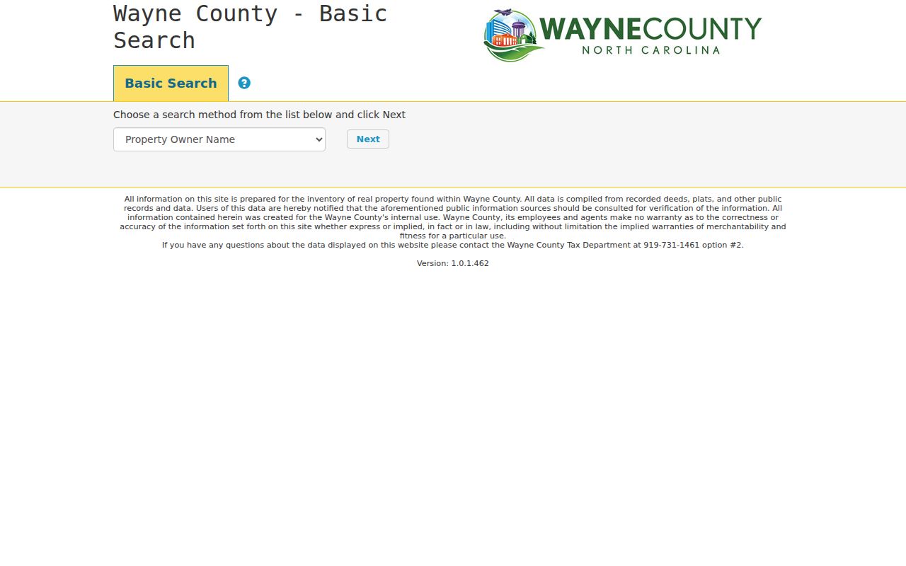
The method selector is a useful starting screen, not proof that every search field or a ZIP filter is available. Record the search date and verify a material result with the Tax office.
Mapping Goldsboro Street Records
The Goldsboro GIS parcel layer adds the map relationship that a tax result lacks. Its display field is OWNERNAME, and its recorded attributes include PIN, REID, PROPADDRESS, DEEDREF, owner mailing fields, sale year and price, acreage, values, neighborhood, exemption code, CITY, and parcel geometry. Search or pan to the target, click the parcel, and then inspect the street segment or nearby polygons. The service supports query, ordering, pagination, distinct values, and distance functions, but research did not verify a one-click whole-street export.
Planning layers can clarify why two nearby Goldsboro addresses fall under different office routes. Available layers include municipal boundaries, ETJ, outside-city limits, zoning, historic district, flood and address information, development, and proposed land use. They provide context, not a list of people. GIS staff are located at 134 N John St, with a listed contact route of 919-731-1650.
- Parcel
- A mapped unit of land used by Tax and GIS. Its PIN or REID can help distinguish similar street numbers.
- Situs address
- The physical property location, shown as
PROPADDRESSin the parcel data. - Plat
- A recorded map of lots, boundaries, and related land details that can connect a street address to a subdivision description.
- Criss-cross directory
- A reverse directory arranged from address to name and phone, useful for historical street work.
Note: A Goldsboro mailing address alone does not prove that a parcel is inside the incorporated city.
Goldsboro Deeds Along a Street
For a Goldsboro street, use the tax owner, PRC, and deed reference to locate the acquisition document. In the ROD index, search the current owner as the grantee, or buyer. Read the seller, the instrument date, and the legal description. Then search that seller as an earlier grantee and require a matching lot, block, subdivision, acreage, adjacent tract, or metes-and-bounds description. A street number can disappear from a deed, so the legal description is the durable match. A grantor is the party transferring an interest; a grantee is the party receiving it.
The Wayne County Land Records guest search displays a Quick Name Search with last or firm name, first name, side, name type, index type, date range, sort, and autocomplete controls. Its instructions direct a user to Document for details and Images for images.
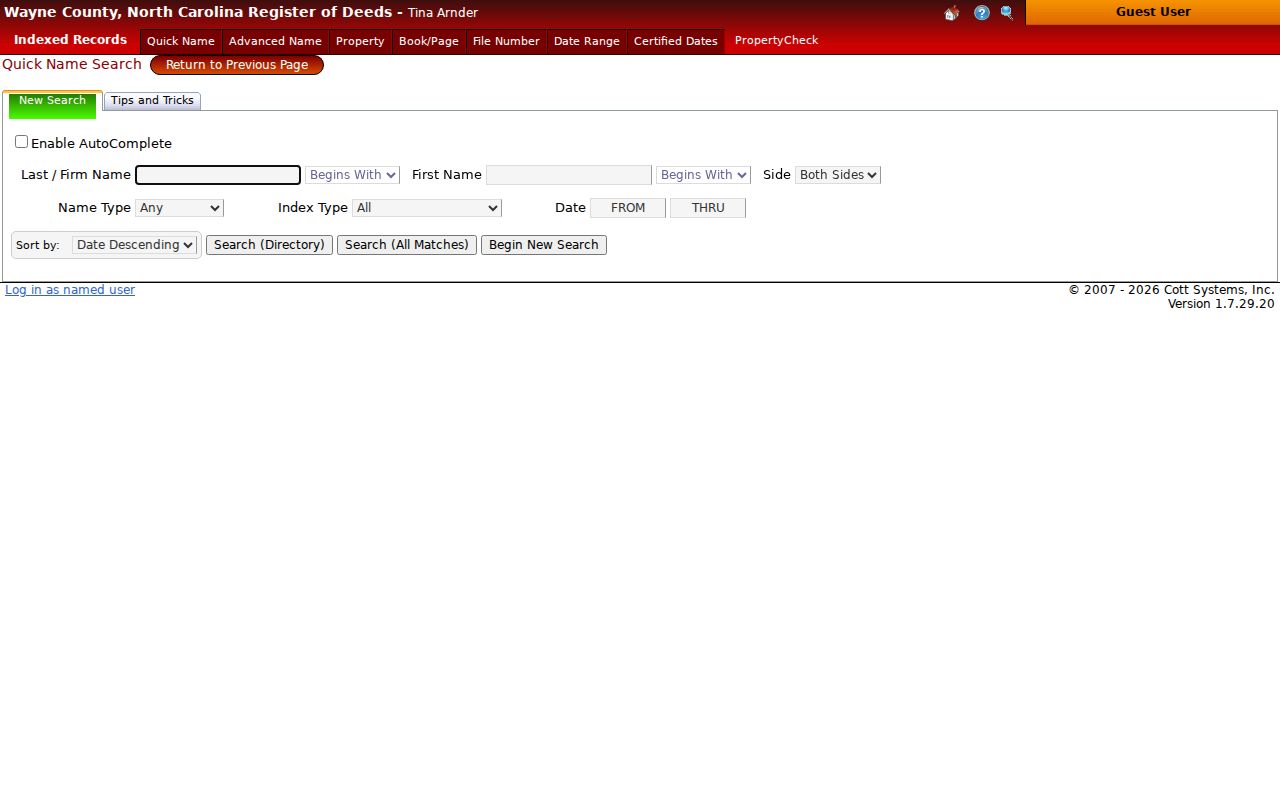
This name-based screen makes the legal description essential when a Goldsboro street address is not in the index result.
Coverage has more than one date reference. The ROD says its records begin in 1913 and that most real estate is online from 1971 forward. Its certified-dates page separately lists a real-estate range from January 1, 1969 through December 31, 1994. Treat those statements as different kinds of coverage evidence, then ask the counter about a specific older book, image, or certification need. The ROD counter is at 224-226 E Walnut St, Suite 100, Goldsboro, and lists 919-731-1449.
The Wayne ROD certified-dates page documents those series-specific windows.
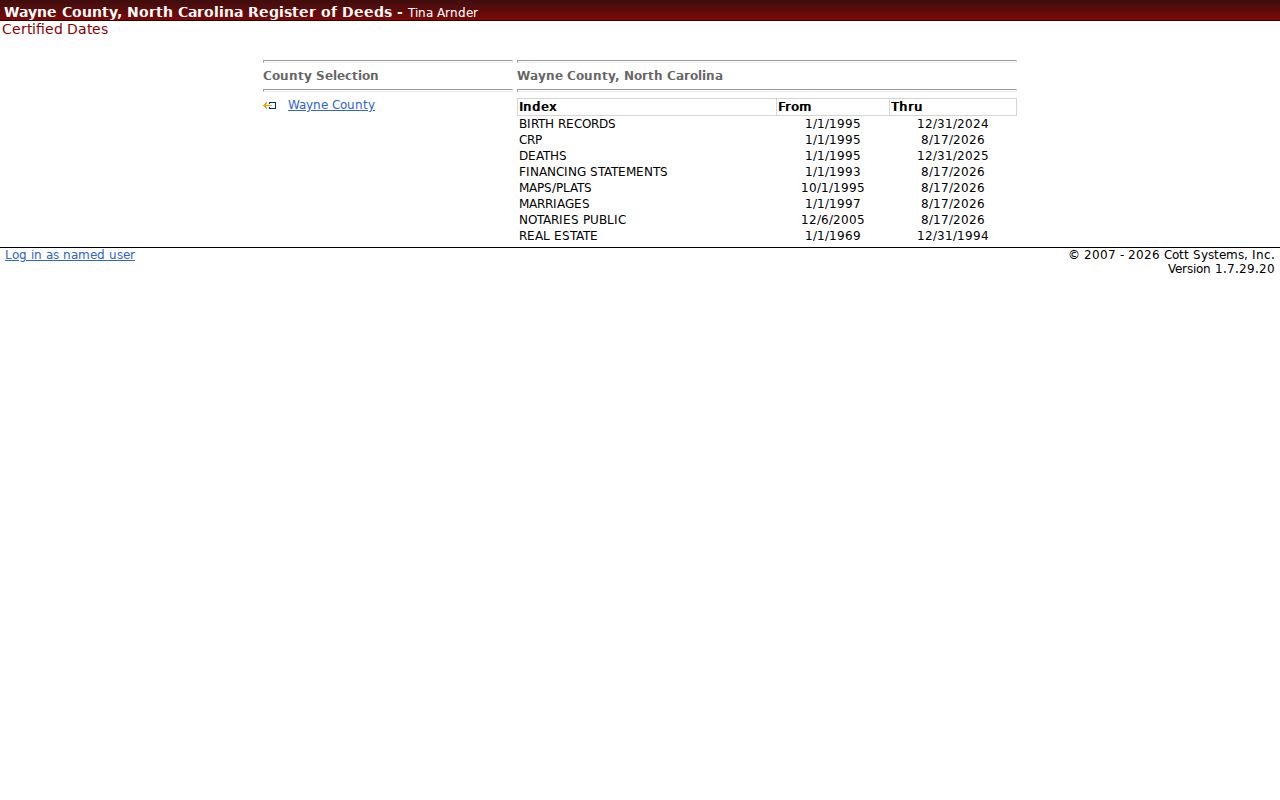
When the online path stops, use the ROD counter, older books, the NC Archives, or a library source rather than guessing across a gap.
Goldsboro Street Records Compared
Each Goldsboro street source answers a different question. The parcel systems are strongest for land identity and an owner of record. Recorded documents establish a legal transaction trail. A directory is a dated historical snapshot. Public voter data is limited by statute and does not create a complete household list. Keeping those limits visible prevents a street search from turning a record connection into an unsupported claim.
| Address-keyed record | Custodian | What it can show | Access and caution |
|---|---|---|---|
| Tax parcel and PRC | Wayne Tax | Assessed owner, co-owner, situs, mailing address, values, tax year, and parcel data | Gateway and PRC, then Tax office verification |
| GIS parcel | Goldsboro GIS | Parcel geometry, owner, deed reference, districts, and neighborhood field | Public map service; the data can change |
| Recorded deeds and plats | Wayne Register of Deeds | Grantor, grantee, instrument trail, and legal description | Guest index and counter; older image status varies |
| Voter record or file | NC SBE and Wayne BOE | Allowed registered-voter fields, status, precinct, and history | Name lookup or authorized file request; protected fields stay withheld |
| Permit record | Goldsboro or Wayne Inspections | Address, work, dates, and publicly visible parties | City or county route depends on jurisdiction; fields were not fully verified |
| Historical directory | WCPL and DigitalNC | Historical address, phone, occupation, or household notation | Annual and incomplete snapshot, not a current assertion |
Wayne County’s public-records coordinator can receive a narrowly described request for an existing county record. North Carolina Public Records Law does not require an agency to create a new street report or analyze separate systems into a new list.
Goldsboro Street Permit Routes
A permit can add a dated address record to a Goldsboro street search. The city’s EnerGov portal exposes Login and Register, but the public anonymous search fields were not verified. Where a public result is available, it may identify an address, work type, permit number, inspection dates, and a listed owner, applicant, or contractor. Those roles corroborate a record event. They do not establish who is at the address now.
Choose the permit custodian from the mapped jurisdiction. Wayne County Inspections says its permit work excludes the City of Goldsboro, Town of Mount Olive, and one-mile ETJs. For a city-held record that is not exposed online, use the City Clerk or Citizen Request route and identify the address, date span, department, and record type. The custodian may withhold exempt material and does not have to build a new address analysis.
Historic Goldsboro Street Directories
For a past Goldsboro street, WCPL’s Hill Donnelly Cross Reference holdings support address-to-name and phone research for 1989, 1990, 1991-93, 1995-99, and current volumes, with gaps to verify. Older Hill’s Goldsboro directories run unevenly from 1911-12 through 1982, while the library guide identifies Goldsboro telephone books from 1968-2003 and current holdings. Search the street exactly as printed, then try an abbreviation or older spelling before deciding it is absent.
The library’s Genealogy and History resources are the local fallback for unscanned editions, reverse books, telephone volumes, microfilm, and the obituary index. The Goldsboro branch is at 1001 E Ash St and lists 919-735-1824. The historical collections are described in more depth in the Goldsboro city directories.
An old entry may reflect the publisher’s date, a business line, a rural route, or a household convention. It is useful evidence for a period, not a statement about a current address.
Read Goldsboro Street Labels
Result labels should stay attached to the source and date. A property owner is a titled party in the tax or deed record. A mailing address is where the owner receives tax notices, and may be elsewhere. A registered voter is a person represented in the election system under the allowed public fields. A permit applicant, contractor, or recorded grantee has a role in that specific record. None of those labels proves that every person connected with an address is present there now.
State voter search requires a known first and last name, and it also uses county, year-of-birth, and status controls. Public voter files protect full birth dates, Social Security numbers, driver-license data, email, and protected addresses. Voter history records election participation, never ballot choices.
Note: When two Goldsboro records conflict, preserve both dates and ask the custodian which field controls its own record.
Goldsboro Streets Near City Lines
Street records can point to different custodians near Goldsboro boundaries. The GIS Planning folder includes ETJ, municipal-boundary, and outside-city-limit layers. County Inspections excludes Goldsboro from much of its permit jurisdiction, so a postal address can be the wrong cue for choosing a permit office. Compare the mapped CITY field and the relevant boundary layer before requesting a permit or a city-held record.
No official source located a complete Goldsboro street-renumbering or street-renaming chronology. For an apparent address break, compare the tax parcel, legal description, plats, historic directory spelling, GIS address layer, and a City Planning or Clerk request. Seymour Johnson Air Force Base was annexed by Goldsboro on February 7, 1977, but that fact is not a universal conversion rule for nearby addresses.
Limits of Goldsboro Street Searches
A Goldsboro street directory can locate public land records and historical address clues, but no one system is a complete roll of people at every parcel. Utility customer lists and DMV address data are not public. The federal DPPA restricts DMV disclosure. North Carolina confidentiality rules also protect sensitive voter fields and the actual addresses of Address Confidentiality Program participants. When no public record supplies the needed fact, the responsible answer is the custodian route, not an inference about a person.
Lawful use. Use Goldsboro street records for a personal, lawful purpose and only the minimum data needed. Do not use an address trail to stalk, threaten, harass, impersonate, or harm anyone.
North Carolina’s anti-stalking and cyberstalking statutes include G.S. 14-277.3A and G.S. 14-196.3. A protected address must not be reconstructed from overlapping records.